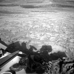
Curiosity Blog, Sols 4573-4574: Welcome to the Uyuni Quad

Written by Lauren Edgar, Planetary Geologist at USGS Astrogeology Science Center

Earth planning date: Monday, June 16, 2025

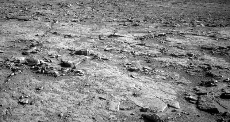
Over the weekend Curiosity successfully wrapped up activities at the “Altadena” drill site and got back on the road. The approximately 48-meter drive (about 157 feet) was successful, and placed the rover in the next mapping quadrangle (informally referred to as a quad).

As a reminder, the rover’s exploration area has been divided into 1.5 kilometer by 1.5 kilometer square quads, and each quad is named after a town of less than 100,000 people. As Curiosity explores features within a quad, we assign informal target names that correspond to geologic formations and features from that town on Earth.

Uyuni, Bolivia, is the gateway city near the world’s largest salt flats (salars), and it seems like an appropriate name as Curiosity explores drier depositional environments higher in the Mount Sharp stratigraphy. The team is excited to use some new target names that will draw from Uyuni and surrounding areas, including the Atacama Desert in Chile, which hosts many Mars analog sites including eolian features, studies of life in extreme environments, and some of the world’s great observatories. A fitting theme for this next phase of exploration!

As for today’s two-sol plan, we have a good balance of contact science, remote sensing, and another long drive. The team planned APXS and MAHLI on a nodular bedrock target named “Flamingo” to assess its chemistry and texture. In the targeted remote sensing block, the science team planned a Mastcam mosaic of “Los Patos” to characterize a depression which may be related to a small impact crater or boxwork structures, along with a Mastcam image of “La Lava” to investigate an interesting dark block. There are also several Mastcam mosaics of nearby troughs to assess active surface processes, and documentation images for ChemCam observations. The plan includes a ChemCam LIBS observation on a target named “Tacos” to assess the local bedrock, and a long-distance RMI mosaic to evaluate sedimentary structures at “Mishe Mokwa” butte. Then the rover will drive about 56 meters (about 184 feet) to the southwest, and take post-drive imaging to prepare for the next plan. On the second sol, Curiosity will complete a ChemCam calibration target activity, a Mastcam data management activity, and a few Navcam activities to monitor clouds and dust in the atmosphere.

We’re looking forward to exploring more of Uyuni as we work our way toward the larger exposure of boxwork structures that lie ahead, and the clues they hold to ancient Mars conditions.

Mars is the fourth planet from the Sun, and the seventh largest. It’s the only planet we know of inhabited…

Explore this collection of Mars images, videos, resources, PDFs, and toolkits. Discover valuable content designed to inform, educate, and inspire,…

Each robotic explorer sent to the Red Planet has its own unique capabilities driven by science. Many attributes of a…

The key to understanding the past, present or future potential for life on Mars can be found in NASA’s four…

Hubble Studies Small but Mighty Galaxy

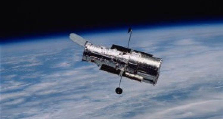
This portrait from the NASA/ESAHubble Space Telescopeputs the nearby galaxy NGC 4449 in the spotlight. The galaxy is situated just 12.5 million light-years away in the constellation Canes Venatici (the Hunting Dogs). It is a member of the M94 galaxy group, which is near the Local Group of galaxies that the Milky Way is part of.

NGC 4449 is a dwarf galaxy, which means that it is far smaller and contains fewer stars than the Milky Way. But don’t let its small size fool you — NGC 4449 packs a punch when it comes to making stars! This galaxy is currently forming new stars at a much faster rate than expected for its size, which makes it a starburst galaxy. Most starburst galaxies churn out stars mainly in their centers, but NGC 4449 is alight with brilliant young stars throughout. Researchers believe that this global burst of star formation came about because of NGC 4449’s interactions with its galactic neighbors. Because NGC 4449 is so close, it provides an excellent opportunity for Hubble to study how interactions between galaxies can influence the formation of new stars.

Hubble releasedan image of NGC 4449 in 2007. This new version incorporates several additional wavelengths of light that Hubble collected for multiple observing programs. These programs encompass an incredible range of science, from a deep dive into NGC 4449’s star-formation history to the mapping of the brightest, hottest, and most massive stars in more than two dozen nearby galaxies.

The NASA/ESA/CSAJames Webb Space Telescopehas also observedNGC 4449, revealing in intricate detail the galaxy’s tendrils of dusty gas, glowing from the intense starlight radiated by the flourishing young stars.

Claire Andreoli(claire.andreoli@nasa.gov)NASA'sGoddard Space Flight Center,Greenbelt, MD

Since its 1990 launch, the Hubble Space Telescope has changed our fundamental understanding of the universe.

NASA Aircraft to Make Low-Altitude Flights in Mid-Atlantic, California

From Sunday, June 22 to Wednesday, July 2, two research aircraft will make a series of low-altitude atmospheric research flights near Philadelphia, Baltimore, and some Virginia cities, including Richmond, as well as over the Los Angeles Basin, Salton Sea, and Central Valley in California.

Pilots will operate the aircraft at altitudes lower than typical commercial flights, executing specialized maneuvers such as vertical spirals between 1,000 and 10,000 feet, circling above power plants, landfills, and urban areas. The flights will also include occasional missed approaches at local airports and low-altitude flybys along runways to collect air samples near the surface.

The East Coast flights will be conducted between June 22 and Thursday, June 26 over Baltimore and near Philadelphia, as well as near the Virginia cities of Hampton, Hopewell, and Richmond. The California flights will occur from Sunday, June 29 to July 2.

The flights, part of NASA’s Student Airborne Research Program (SARP), will involve the agency’s Airborne Science Program’s P-3 Orion aircraft (N426NA) and a King Air B200 aircraft (N46L) owned by Dynamic Aviation and contracted by NASA. The program is an eight-week summer internship program that provides undergraduate students with hands-on experience in every aspect of a scientific campaign.

The P-3, operated out ofNASA’s Wallops Flight Facilityin Virginia, is a four-engine turboprop aircraft outfitted with a six-instrument science payload to support a combined 40 hours of SARP science flights on each U.S. coast. The King Air B200 will fly at the same time as the P-3 but in an independent flight profile. Students will assist in the operation of the science instruments on the aircraft to collect atmospheric data.

“The SARP flights have become mainstays of NASA’s Airborne Science Program, as they expose highly competitive STEM students to real-world data gathering within a dynamic flight environment,” said Brian Bernth, chief of flight operations at NASA Wallops.

“Despite SARP being a learning experience for both the students and mentors alike, our P-3 is being flown and performing maneuvers in some of most complex and restricted airspace in the country,” said Bernth. “Tight coordination and crew resource management is needed to ensure that these flights are executed with precision but also safely.”

For more information about Student Airborne Research Program, visit:

https://science.nasa.gov/earth-science/early-career-opportunities/student-airborne-research-program/

ByOlivia LittletonNASA’s Wallops Flight Facility, Wallops Island, Va.

NASA History News and Notes – Summer 2025

In the summer 2025 issue of the NASA History Office’sNews & Notesnewsletter, examples of leadership and critical decision-making in NASA’s history form the unifying theme. Among the topics discussed are NASA’s Shuttle-Centaur program, assessing donations to the NASA Archives, how the discovery of the first exoplanet orbiting a sun-like star catalyzed NASA’s exoplanet program, and Chief of the Medical Operations Office Charles A. Berry’s decisions surrounding crew health when planning the Project Gemini missions.

NASA’s is a history markedby critical decisions. From George Mueller’s 1963 decision for “all up” testing of the Saturn V rocket to Michael Griffin’s 2006 decision to launch a final servicing mission to the Hubble Space Telescope, the agency has continually met key inflection points with bold decisions. These choices, such as the decision to send a crewed Apollo 8 mission around the Moon in December 1968, stand at the center of the agency’s national legacy and promote confidence in times of crisis.Continue Reading

“Although the Shuttle/Centaur decision was very difficult to make, it is the proper thing to do, and this is the time to do it.” With those words on June 19, 1986, NASA Administrator James Fletcher canceled the intensive effort to integrate the Centaur upper stage with the Space Shuttle to launch the Galileo and Ulysses spacecraft. The decision, which was tied to increased safety measures following the loss of Challenger several months earlier, brought to the forefront the 1970s decision to launch all U.S. payloads with the Space Shuttle.Continue Reading

On January 27, 1967,Mission AS-204 (later known as Apollo 1) was conducting a simulated countdown when a fire suddenly broke out in the spacecraft, claiming the lives of astronauts Virgil I. “Gus” Grissom, Edward H. White, and Roger B. Chaffee. The disaster highlighted the risks that come with spaceflight and the work that still needed to be accomplished to meet President Kennedy’s challenge of going to the Moon before the end of the decade. With the complexity of the Apollo spacecraft, discerning the cause of the fire proved to be incredibly difficult.Continue Reading

Robert MacDonald, the manager of NASA’s Large Area Crop Inventory Experiment (LACIE), was not pleased in January 1978 after he read a draft copy of the U.S. General Accounting Office’s (GAO’s) “Crop Forecasting by Satellite: Progress and Problems” report. The draft’s authors argued that LACIE had not achieved its goals of accurately predicting harvest yields in the mid-1970s. Therefore, congressional leaders should “be aware of the disappointing performance of LACIE to date when considering the future direction of NASA’s Landsat program and the plans of the Department of Agriculture.”Continue Reading

This year, NASA commemorates 35 years of the Hubble Space Telescope’s study of the cosmos. From observations of never-before-seen phenomena within our solar system, to the discovery of distant galaxies, the confirmation of the existence of supermassive black holes, and precision measurements of the universe’s expansion, Hubble has made incredible contributions to science, technology, and even art. Yet, for all its contemporary popularity, the Hubble program initially struggled for congressional approval and consequential funding. For its part, NASA found new ways to compromise and cut costs, while Congress evaluated national priorities and NASA’s other space exploration endeavors against the long-range value of Hubble.Continue Reading

The major functions of an archivist center include appraising, arranging, describing, preserving, and providing access to historical records and documents. While together these are pillars of archival science, they are more of an art than a science in their application, fundamentally necessitating skilled decision making. Throughout the NASA archives, staff members make these decisions day in and day out.Continue Reading

On October 20, 1995, theNew York Timesreported the detection of a distant planet orbiting a Sun-like star.The star, catalogued as 51 Pegasi by John Flamsteed in the 18th century, was visible to the naked eye as part of the constellation Pegasus—and had wobbled on its axis just enough that two Swiss astronomers were able to deduce the presence of another object exerting its gravitational pull on the star’s rotation. The discovery was soon confirmed by other astronomers, and 51 Pegasi b was heralded as the first confirmed exoplanet orbiting a star similar to our own Sun.Continue Reading

In 1963, critical decisions had to be made about NASA’s upcoming Gemini missions if the nation were to achieve President John F. Kennedy’s lunar goals. Known as the bridge to Apollo, Project Gemini was critical to landing a man on the Moon by the end of the decade and returning him safely to Earth. The project would demonstrate that astronauts could rendezvous and dock their spacecraft to another space vehicle and give flight crews the opportunity to test the planned extravehicular capabilities in preparation for walking on the lunar surface on future Apollo flights. Perhaps most importantly, Gemini had to show that humans could live and work in space for long periods of time, a fiercely debated topic within and outside of the agency.Continue Reading

As we walked into Bob McCall’s Arizona home, it quickly became obvious that two talented and creative people lived there. Tasked with interviewing one of the first artists to be invited to join the NASA Art Program, our oral history team quickly realized the session with McCall would include a unique perspective on NASA’s history. We traveled to Arizona in the spring of 2000 to capture interviews with some of the pioneers of spaceflight and had already talked to an eclectic group of subjects in their homes, including a flight controller for both Gemini and Apollo, an astronaut who had flown on both Skylab and Space Shuttle missions, a former NASA center director, and two former Women’s Airforce Service Pilots (WASPs) who ferried airplanes during WWII. However, unlike most interviews, the setting itself provided a rare glimpse into the man and his inspiration.Continue Reading

The Biomedical Branch Files (1966–2008) in the Johnson Space Center archives showcase the inner workings of a NASA office established to perform testing to provide a better understanding of the impacts of spaceflight on the human body. Ranging from memos and notes to documents and reports, this collection is an invaluable resource on the biomedical research done with NASA’s Apollo, Skylab, Space Shuttle, and Space Station projects. Files in the collection cover work done by groups within the branch such as the Toxicology, Microbiology, Clinical, and Biochemistry Laboratories. It also reveals the branch’s evolution and changes in its decision-making process over the years.Continue Reading

History Publications and Resources

Summer Begins in Northern Hemisphere

This full-disk image from NOAA’s GOES-13 satellite was captured at 7:45 a.m. EDT (11:45 UTC) and shows the Americas on June 21, 2012, the start of astronomical summer – in the Northern Hemisphere – that year.

The first day of summer in 2025 is June 20; it is also the longest day of the year. In the Southern Hemisphere, it’s the shortest day of the year and the beginning of winter.

Earth orbits at an angle, so the Northern Hemisphere is tilted toward the Sun half of the year — this is summer in the Northern Hemisphere, and winter in the Southern Hemisphere. The other half of the year, the Northern Hemisphere is tilted away from the Sun, creating winter in the north and summer in the south. Solstices happen twice per year, at the points in Earth’s orbit where this tilt is most pronounced.

NASA Air Taxi Passenger Comfort Studies Move Forward

NASA’s Advanced Air Mobility vision involves the skies above the U.S. filled with new types of aircraft, including air taxis. But making that vision a reality involves ensuring that people will actually want to ride these aircraft – which is why NASA has been working to evaluate comfort, to see what passengers will and won’t tolerate.

NASA is conducting a series of studies to understand how air taxi motion, vibration, and other factors affect ride comfort. The agency will provide the data it gathers to industry and others to guide the design and operational practices for future air taxis.

“The results of this study can guide air taxi companies to design aircraft that take off, land, and respond to winds and gusts in a way that is comfortable for the passengers,” said Curt Hanson, senior flight controls researcher for this project based at NASA’s Armstrong Flight Research Center in Edwards, California. “Passengers who enjoy their experience in an air taxi are more likely to become repeat riders, which will help the industry grow.”

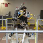
The air taxi comfort research team uses NASA Armstrong’s Ride Quality Laboratory as well as the Human Vibration Lab and Vertical Motion Simulator at NASA’s Ames Research Center in California’s Silicon Valley to study passenger response to ride quality, as well as how easily and precisely a pilot can control and maneuver aircraft.

Afterpilots checked outthe simulator setup, the research team conducted a study in October where NASA employees volunteered to participate as passengers to experience the virtual air taxi flights and then describe their comfort level to the researchers.

Using this testing, the team produced an initial study that found a relationship between levels of sudden vertical motion and passenger discomfort. More data collection is needed to understand the combined effect of motion, vibration, and other factors on passenger comfort.

“In the Vertical Motion Simulator, we can investigate how technology and aircraft design choices affect the handling qualities of the aircraft, generate data as pilots maneuver the air taxi models under realistic conditions, and then use this to further investigate passenger comfort in the Ride Quality and Human Vibration Labs,” said Carlos Malpica, senior rotorcraft flight dynamics researcher for this effort based at NASA Ames.

This work is managed by theRevolutionary Vertical Lift Technologyproject under NASA’sAdvanced Air Vehicles Programin support of NASA’sAdvanced Air Mobility mission, which seeks to deliver data to guide the industry’s development of electric air taxis and drones.

Armstrong Flight Research Center

NASA’s LRO Views ispace HAKUTO-R Mission 2 Moon Lander Impact Site

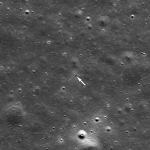
On June 11, NASA’s LRO (Lunar Reconnaissance Orbiter) captured photos of the site where the ispace Mission 2 SMBC x HAKUTO-R Venture Moon (RESILIENCE) lunar lander experienced a hard landing on June 5, 2025, UTC.

RESILIENCE was launched on Jan. 15 on a privately funded spacecraft.

LRO’s right Narrow Angle Camera (one in a suite of cameras known asLROC) captured the images featured here from about 50 miles above the surface of Mare Frigoris, a volcanic region interspersed with large-scale faults known as wrinkle ridges.

The dark smudge visible above the arrow in the photo formed as the vehicle impacted the surface, kicking up regolith — the rock and dust that make up Moon “soil.” The faint bright halo encircling the site resulted from low-angle regolith particles scouring the delicate surface.

LRO is managed byNASA’s Goddard Space Flight Centerin Greenbelt, Maryland, for the Science Mission Directorate at NASA Headquarters in Washington. Launched on June 18, 2009, LRO has collected a treasure trove of data with its seven powerful instruments, making an invaluable contribution to our knowledge about the Moon. NASA is returning to the Moon with commercial and international partners to expand human presence in space and bring back new knowledge and opportunities.

More on this story from Arizona State University’s LRO Camera website

Media ContactKaren Fox / Molly WasserHeadquarters, Washington202-358-1600karen.c.fox@nasa.gov/molly.l.wasser@nasa.gov

Lonnie ShekhtmanNASA’s Goddard Space Flight Center, Greenbelt, Md.lonnie.shekhtman@nasa.gov

NASA Tech to Use Moonlight to Enhance Measurements from Space

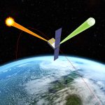
NASA will soon launch a one-of-a-kind instrument, called Arcstone, to improve the quality of data from Earth-viewing sensors in orbit. In this technology demonstration, the mission will measure sunlight reflected from the Moon— a technique called lunar calibration. Such measurements of lunar spectral reflectance can ultimately be used to set a high-accuracy, universal standard for use across the international scientific community and commercial space industry.

To ensure satellite and airborne sensors are working properly, researchers calibrate them by comparing the sensor measurements against a known standard measurement. Arcstone will be the first mission exclusively dedicated to measuring lunar reflectance from space as a way to calibrate and improve science data collected by Earth-viewing, in-orbit instruments.

To view this video please enable JavaScript, and consider upgrading to a web browser thatsupports HTML5 video

“One of the most challenging tasks in remote sensing from space is achieving required instrument calibration accuracy on-orbit,” said Constantine Lukashin, principal investigator for the Arcstone mission and physical scientist at NASA’s Langley Research Center in Hampton, Virginia. “The Moon is an excellent and available calibration source beyond Earth’s atmosphere. The light reflected off the Moon is extremely stable and measurable at a very high level of detail. Arcstone’s goal is to improve the accuracy of lunar calibration to increase the quality of spaceborne remote sensing data products for generations to come.”

Across its planned six-month mission, Arcstone will use a spectrometer — a scientific instrument that measures and analyzes light by separating it into its constituent wavelengths, or spectrum — to measure lunar spectral reflectance. Expected to launch in late June as a rideshare on a small CubeSat, Arcstone will begin collecting data, a milestone called first light, approximately three weeks after reaching orbit.

“The mission demonstrates a new, more cost-efficient instrument design, hardware performance, operations, and data processing to achieve high-accuracy reference measurements of lunar spectral reflectance,” said Lukashin.

To view this video please enable JavaScript, and consider upgrading to a web browser thatsupports HTML5 video

Measurements of lunar reflectance taken from Earth’s surface can be affected by interference from the atmosphere, which can complicate calibration efforts. Researchers already use the Sun and Moon to calibrate spaceborne instruments, but not at a level of precision and agreement that could come from having a universal standard.

Lukashin and colleagues want to increase calibration accuracy by getting above the atmosphere to measure reflected solar wavelengths in a way that provides a stable and universal calibration source. Another recent NASA mission, called the Airborne Lunar Spectral Irradiance mission also used sensors mounted onhigh-altitude aircraftto improve lunar irradiance measurements from planes.

There is not an internationally accepted standard (SI-traceable) calibration for lunar reflectance from space across the scientific community or the commercial space industry.

“Dedicated radiometric characterization measurements of the Moon have never been acquired from a space-based platform,” said Thomas Stone, co-investigator for Arcstone and scientist at the U.S. Geological Survey (USGS). “A high-accuracy, SI-traceable lunar calibration system enables several important capabilities for space-based Earth observing missions such as calibrating datasets against a common reference – the Moon, calibrating sensors on-orbit, and the ability to bridge gaps in past datasets.”

If the initial Arcstone technology demonstration is successful, a longer Arcstone mission could allow scientists to make the Moon the preferred reference standard for many other satellites. The new calibration standard could also be applied retroactively to previous Earth data records to improve their accuracy or fill in data gaps for data fields. It could also improve high-precision sensor performance on-orbit, which is critical for calibrating instruments that may be sensitive to degradation or hardware breakdown over time in space.

“Earth observations from space play a critical role in monitoring the environmental health of our planet,” said Stone. “Lunar calibration is a robust and cost-effective way to achieve high accuracy and inter-consistency of Earth observation datasets, enabling more accurate assessments of Earth’s current state and more reliable predictions of future trends.”

The Arcstone technology demonstration project is funded by NASA’sEarth Science Technology Office’sIn-space Validation of Earth Science Technologies. Arcstone is led by NASA’sLangley Research Centerin partnership withColorado University Boulder’s Laboratory for Atmospheric and Space Physics,USGS,  NASAGoddard Space Flight Centerin Greenbelt, Maryland,Resonon Inc.,Blue Canyon Technologies, andQuartus Engineering.

For more information on NASA’s Arcstone mission visit:

https://science.larc.nasa.gov/arcstone/about/

Curiosity Blog, Sols 4575-4576: Perfect Parking Spot

Written by Lucy Thompson, APXS Collaborator and Senior Research Scientist at the University of New Brunswick

Earth planning date: Wednesday, June 18,  2025

Not only did our drive execute perfectly, Curiosity ended up in one of the safest, most stable parking spots of the whole mission. We often come into the start of planning hoping that all the wheels are safely on the ground, but the terrain on Mars is not always very cooperative. As the APXS strategic planner I was really hoping that the rover was stable enough to unstow the arm and place APXS on a rock — which it was! We are acquiring APXS and ChemCam compositional analyses and accompanying Mastcam and MAHLI imaging of a brushed, flat, typical bedrock target, “Tarija.” This allows us to track the chemistry of the bedrock that hosts the potential boxwork features that we are driving towards.

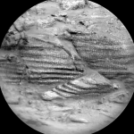
As well as composition, we continue to image the terrain around us to better understand the local and regional context. Mastcam will acquire mosaics of some linear ridges off to the north of our current location, as well as of a potential fracture fill just out in front of our current parking spot, “Laguna del Bayo.” ChemCam will image part of an interesting outcrop (“Mishe Mokwa”) that we have already observed (see the image associated with this blog).

Thanks to the relatively benign terrain, the engineers have planned a 54-meter drive (about 177 feet) to our next location. After that drive (hopefully) executes successfully, we have a series of untargeted science observations. MARDI will image the terrain beneath the wheels and ChemCam will pick a rock target autonomously from our new workspace and analyze its chemistry.

To track atmospheric and environmental fluctuations, we are acquiring a Mastcam tau to measure dust in the sky as well as a Navcam large dust-devil survey and suprahorizon movie. The plan is rounded, as always, with standard DAN, REMS, and RAD activities.

Mars is the fourth planet from the Sun, and the seventh largest. It’s the only planet we know of inhabited…

Explore this collection of Mars images, videos, resources, PDFs, and toolkits. Discover valuable content designed to inform, educate, and inspire,…

Each robotic explorer sent to the Red Planet has its own unique capabilities driven by science. Many attributes of a…

The key to understanding the past, present or future potential for life on Mars can be found in NASA’s four…

Curiosity Blog, Sols 4577-4579: Watch the Skies

Written by Deborah Padgett, OPGS Task Lead at NASA's Jet Propulsion Laboratory

Earth planning date: Friday, June 20, 2025

During the plan covering Sols 4575-4576, Curiosity continued our investigation of mysterious boxwork structures on the shoulders of Mount Sharp. After a successful 56-meter drive (about 184 feet), Curiosity is now parked in a trough cutting through a highly fractured region covered by linear features thought to be evidence of groundwater flow in the distant past of Mars. With all six wheels firmly planted on solid ground, our rover is ready for contact science! Unfortunately, a repeat of the frost-detection experiment expected for the weekend plan is postponed for a few days due to a well-understood ChemCam issue. In the meantime, our atmospheric investigations have a chance to shine, as they received additional time to observe the Martian sky.

In the early afternoon of Sol 4577, Curiosity’s navigation cameras will take a movie of the upper reaches of Aeolis Mons (Mount Sharp), hoping to see moving cloud shadows. This observation enables the team to calculate the altitude of clouds drifting over the peak. Next, Navcam will point straight up, to image cloud motion at the zenith and determine wind direction at their altitude. Mastcam will then do a series of small mosaics to study the rover workspace and features of the trough that Curiosity has entered. First is a 6×4 stereo mosaic of the workspace and the contact science targets “Copacabana” and “Copiapo.” The first target is a representative sample of the trough bedrock, and its name celebrates a town in Bolivia located on the shores of Lake Titicaca. The second target is a section of lighter-toned material, which may be associated with stripes or “veins” filling the many crosscutting fractures in the local stones. These are the deposits potentially left by groundwater intrusion long ago. The name “Copiapo” honors a silver mining city in the extremely dry Atacama desert of northern Chile. A second 6×3 Mastcam stereo mosaic will look at active cracks in the trough. Two additional 5×1 Mastcam stereo mosaics target “Ardamarca,” a ridge parallel to the trough walls, and a cliff exposing layers of rock at the base of “Mishe Mokwa” butte. At our current location, all the Curiosity target names are taken from the Uyuni geologic quadrangle named after the otherworldly lake bed and ephemeral lake high on the Bolivian altiplano, but the Mishe Mokwa butte is back in the Altadena quad, named for a popular hiking trail in the Santa Monica Mountains. After this lengthy science block, Curiosity will deploy its arm, brush the dust from Copacabana with the DRT, then image both it and Copiapo with the MAHLI microscopic imager. Overnight, APXS will determine the composition of these two targets.

Early in the morning of Sol 4578, Mastcam will take large 27×5 and 18×3 stereo mosaics of different parts of the trough, using morning light to highlight the terrain shadows. Later in the day, Navcam will do a 360 sky survey, determining phase function across the entire sky. A 25-meter drive (about 82 feet) will follow, and the post-drive imaging includes both a 360-degree Navcam panorama of our new location and an image of the ground under the rover with MARDI in the evening twilight. The next sol is all atmospheric science, with an extensive set of afternoon suprahorizon movies and a dust-devil survey for Navcam, as well as a Mastcam dust opacity observation. The final set of observations in this plan happens on the morning of Sol 4580 with more Navcam suprahorizon and zenith movies to observe clouds, a Navcam dust opacity measurement across Gale Crater, and a last Mastcam tau. On Monday, we expect to plan another drive and hope to return to the frost-detection experiment soon as we explore the boxwork canyons of Mars.

Mars is the fourth planet from the Sun, and the seventh largest. It’s the only planet we know of inhabited…

Explore this collection of Mars images, videos, resources, PDFs, and toolkits. Discover valuable content designed to inform, educate, and inspire,…

Each robotic explorer sent to the Red Planet has its own unique capabilities driven by science. Many attributes of a…

The key to understanding the past, present or future potential for life on Mars can be found in NASA’s four…

Tidak Ada Lagi Postingan yang Tersedia.

Tidak ada lagi halaman untuk dimuat.